- Site Indexes
- Search by Keyword
- Search by Topic
- Search by Place
- Things to Do
- Entertainment
- Recreation
- History
- Basics
- Accommodations
- Have Some Fun
- Fun Stuff
- Kid Stuff
- Food and Recipes
- Send a Postcard
- Wallpaper
- Our Site
- Site Info
- Contact Us
- Home
xxxx
xxx

x
Home > Recreation > State ParksStony Brook State Park
Dansville, NY 14437 585-335-8111 Services: A,G,I,J,L,M,O,P,Q, R,S,V,X,Y,Z,BB,CC
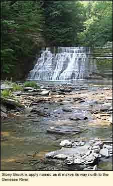
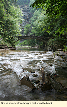
LOCATIONStony Brook State Park is located in the Town of Dansville in Steuben County directly south of the Village of Dansville in Livingston County. If you are coming via State Route 390, take Exit 4 and follow the signs. The park is linear, running north and south with and entrance at each end. When you exit off State Route 390, the first entrance you come to will be the "lower" or north entrance. The pool, main picnic area, playground, and other facilities are at this end. The south end of the park, called the "upper" entrance, is mainly camping and where you will need to check in if you wish to reserve a camp site. HISTORYHundreds of years ago, the land that is now Stony Brook State Park was frequented by the Seneca Nation of Indians, the Keepers of the Western Door. When the Senecas were driven out of the region after the Revolutionary War, the land was farmed and mills were built on Stony Brook. In 1833, a railroad was constructed th
Natural gas was discovered by the Indians as it bubbled up through the water in the lower park. But it wasn't until the late 1800s that it was eventually captured and used for lighting and cooking.
In the 1930s, the park was a Civilian Conservation Corps (CCC) camp. The CCC was a government program that put Depression-era men to work in parks around the country. The built trails, stone walls and walks, and buildings. Many of the beautiful, old, moss-covered stone walls and walks in Stony Brook were built by the CCC. FACILITIESToday Stony Brook State Park's terrain comprises hilly woodlands, a deep gorge with rugged cliffs overlooking numerous waterfalls (not three as the Ball FieldsThe park has a large open area of mowed grass at the lower entrance that is ideal for soccer, baseball, and even croquet. There is a badminton net and a small grassy area in the upper campground. BirdingBirding is best in the spring and away from the gorge. The rim trails and the upper campground should provide many opportunities to warblers, thrushes, nuthatches, woodpeckers, and other woodland birds. Beware, though, that many of the trees are quite tall. CampingCamping is available from the first weekend in May to mid-October. There are 125 non-electric tent and trailer campsites, most of which are in the southern part of the park. Tent camping is also permitted just off the east rim trail in a deeply wooded area with little ground vegetation. (The east rim campground is not recommended for children as there is little for them to do there.)
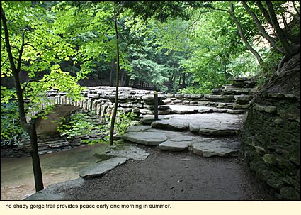
In the upper campground, almost all of the camp sites are in the woods with tall trees creating shade. Each site has a picnic table and a fire ring but no water hook-ups. Water spigots are located throughout the campground, as are bathrooms. There camp store but no laundry, a HikingThe park has three main trails: the gorge trail, which is the most scenic; the east rim trail; and the west rim trail. Because the park rises steeply in elevation from the lower entrance to the upper entrance (north to south), you should begin your walk at the lower entrance and walk through the gorge trail. It is walking in this direction that you can best appreciate the many interesting geological sites in the gorge. When you get to the top of the gorge, you can choose whether to take the east or the west rim downhill. Whichever you select, they will both be steep. There are hundred of stair steps on these three trails. You should attempt them only if you are physically able. Wear shoes appropriate for hiking, and bring something to drink.
Besides the three main trails, there are numerous shorter spur trails coming off the rim trails. These are not marked on the park map, nor are they marked in the woods. A GPS is recommended for exploring off the main trails. Don't expect a cell phone to save you if you get lost. Cell phone service is spotty in the park. PhotographyThe gorge trail provides access to may photo opportunities, however, because of the shadiness of the gorge, a tripod is highly recommended. The rim trails are especially nice in the spring when native wildflowers are in bloom.
PlaygroundsThe park has two playgrounds: a large one at the lower entrance that even young adults seem to find a challenge, and a small one in the campground at the upper entrance.
Winter ActivitiesIn winter, three miles of cross-country trails are available for skiers. Some winter hiking and snowshoeing is allowed, but not on the gorge trails. There is a marked snowmobile trail through the park. PETSPets must be leashed everywhere in the park.
Park plan and camping area map (pdf) WITHIN EASY DRIVING DISTANCEKEY TO SERVICESA-Beach B-Biking C-Boat Launch Sites
E-Cabins F-Camper Recreation G-Campsites H-Dockage I-Dumping Station J-Empire Passport Accepted K-Fishing L-Food M-Hiking N-Marina O-Nature Trail P-Pavilions Q-Picnic Tables R-Playground S-Playing Fields T-Powerboats U-Recreation Programs V-Showers W-Sledding X-Snowmobiling Y-Snowshoeing Z-Tent/Trailer Sites AA-Vacation Rentals BB-X-Country Skiing CC-Scenic Views DD-All above
Updated 6 Janaury 2013
|
 10820 State Route 36
 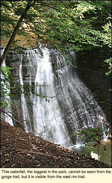 at brought in tourists to the train station, which was located where the campground office is today. These tourists enjoyed hiking, picnicking, an outdoor theater, and dancing in a dance hall. The railroad tracks are now gone, but the supports are still visible in the creek.
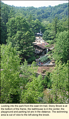 park brochure states), and fascinating rock formations. Visitors can hike rim, gorge, or nature trails, play tennis on park courts, picnic, or swim in either of two stream-fed pools.
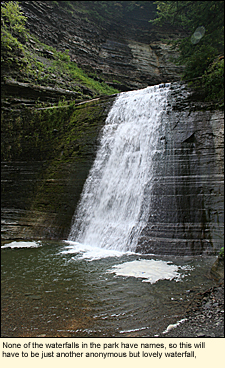 small playground, and access to the trails. The roads are paved and ideal for bike riding. Group camping is permitted, alcohol is not.
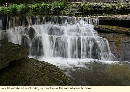
 D-Boat Rentals
|
|